
I hope everyone has enjoyed our little summerlike vacation. Within the next few days, we snap back to reality and jointhe calendar in October because of a cold front. Central Oregon’s Weather is about to flip quickly into Autumn. We’re squeezing out one day of sunshine and 80s. But, the changes we’ve been talking about are getting closer. Friday brings wind, clouds and the beginning of a pretty impressive cooldown. By the weekend, we’ll be trading short sleeves for jackets, and by early next week, some of us may be looking for the windshield scraper.
And here’s the interesting part: The cold air is looking a whole lot more impressive than the precipitation.
Temperatures have been running close to where we were 24-hours ago, with afternoon highs mostly headed into the 80s. This keeps our high temperatures running 10° to 20° above average (Average: Bend- 67/35 | Redmond 69/35) for early October.
Heads up for everyone- A Freeze Watch has been issued for parts of Central Oregon. It will go into effect for portions of (lower elevations) Jefferson, Crook and Deschutes county until 10am Saturday 10/10.
Sub-freezing temperatures are on the way this weekend. Through early next week, Sunday/Monday/Tuesday mornings will be even colder with lows in the 20s… Maybe even some teens.
The Big Picture:
High pressure is still anchored over the PNW coastline- giving us one final warm, sunny day before a system (approaching from the Gulf of Alaska) changes the pattern. Friday is our transition day, with increasing clouds, gusty winds and falling temperatures. The weekend brings a much colder air mass, a few opportunities for showers and perhaps some light snow over the higher terrain. But don’t expect a big soaking or to be able to measure snow. The latest forecast guidance continues to favor very little precipitation across much of Deschutes, Crook and Jefferson counties. What is becoming increasingly clear is the upcoming cooldown will bring big changes and a couple nights of a hard freeze.
One interesting feature of this transition is the shift from a relatively amplified ridge to a more progressive northern-stream pattern. As the ridge axis moves east, the Pacific Northwest becomes increasingly exposed to disturbances moving south from higher latitudes. That change in the upper-level flow is important because it allows a much colder air mass to reach Central Oregon without requiring a particularly deep or moisture-rich Pacific storm.
What’s Next:
A broad and strong ridge of high pressure has been responsible for these sunny afternoons and temperatures that feel more like late summer than the second week of October. High pressure is beginning to flatten. As our ridge breaks down, our next system will move into the Pacific Northwest.
The first noticeable change arrives Friday. With more clouds, the pressure gradient tightens and west to northwest winds pick up. Gusts will strengthen to 25–35 mph for some, across the open High Desert. Couple stronger winds with very dry conditions, and we have fire weather concerns. Afternoon relative humidity today is expected to fall into the teens and lower 20s in many areas. While humidity should begin recovering as the front approaches, Friday’s stronger winds could still create problems where vegetation remains dry.
Now, about that weekend system- this is shaping up to be a much better cold-air producer than precipitation-maker. The upper-level trough will bring cooler air into the region, but the available moisture looks limited.
As northwest flow encounters the Cascades, the mountains have a better opportunity to squeeze out showers. East of the crest, descending air tends to dry out, leaving much of the High Desert with clouds, cooler temperatures and relatively little precipitation. Translation? The atmosphere is bringing us a change of seasons, not necessarily a change in our drought of meaningful rainfall.
The latest suite of forecast model guidance is particularly dry across our lower elevations, with little measurable precipitation indicated through Saturday. That doesn’t rule out a passing sprinkle, but it certainly doesn’t suggest a widespread rain event.
Let’s Take This Day by Day:
Tonight– Changes are waiting in the wings. Few clouds until the AM hours and cool. Lows in the 40s with a few 30s and a gentle breeze. Winds begin turning more southwesterly ahead of Friday’s approaching system.
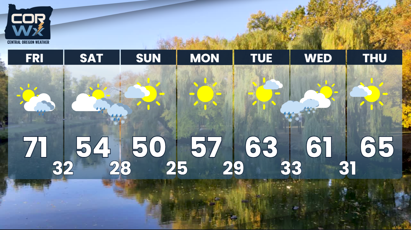
Friday– Here come the clouds and the wind. Somebody might want to check on the patio furniture… and maybe the trash cans. Clouds increase as the cold front approaches, and winds become the main story. Expect gusts reaching into the 25-35mph range for many, as they swing around to the Northwest. Highs in the 60s and lower 70s. That’s already a noticeable step down from today.
Blowing dust could become an issue along open stretches of highway and across agricultural areas.
Saturday– October takes over our weather pattern. If you think we are in for a big “feels like” difference for Friday, wait until Saturday. Highs struggle to warm out of the 40s and into the 50s, with even colder conditions over higher terrain. Expect a mix of clouds and occasional sunshine, some lingering breezes and some light showers, particularly closer to the mountains.
It won’t be an all-day washout. In fact, plenty of locations may stay dry altogether.
Sunday– Jackets Required. We’re settling into a considerably colder weather pattern.
Highs generally remain in the 40s and 50s, with partly to mostly cloudy skies and a few lingering AM showers possible- some snowflakes are expected. And don’t overlook those morning temperatures. Freezing conditions become a real possibility across many of our colder communities.
Extended Outlook: The Coldest Part May Come After the Storm
Here’s something I find particularly interesting about this setup- our approaching trough is certainly responsible for our weekend cooldown, but the coldest mornings may arrive after the system begins moving away.
As the atmosphere dries out, cloud cover decreases and winds relax, we create favorable conditions for radiational cooling. The ground loses heat efficiently overnight, and cold air collects in our valleys and other sheltered locations. That’s why some communities could see temperatures well into the 20s early next week, even as afternoon temperatures begin to recover. And that recovery is showing up in the latest guidance.
By Tuesday and Wednesday (next week), temperatures should gradually climb back toward more seasonable levels, with afternoon highs returning to the upper 50s and 60s across much of the region. So, the weekend chill doesn’t necessarily signal the beginning of an extended stretch of winter-like weather. It looks more like a sharp interruption followed by a gradual rebound.
Impacts: A Few Things Worth Your Attention
Fire weather– Very dry conditions today, followed by gusty winds Friday, mean we still need to be careful with anything that could start a fire.
Travel– Blowing dust and crosswinds may affect exposed highways Friday, particularly across open areas of the High Desert.
Outdoor plans– Saturday and Sunday will feel dramatically different from today. Plan for colder temperatures, occasional breezes and a few possible showers.
Freezing temperatures– Sensitive plants and exposed irrigation equipment deserve attention heading into the weekend and early next week.
Final Thoughts:
You know, Central Oregon has a funny way of reminding us that the calendar isn’t just a suggestion. We can spend the first week of October enjoying afternoons that belong in August, and then (almost overnight) we’re talking about gusty winds, mountain snowflakes and freezing mornings.
That’s exactly where we’re headed. Enjoy today’s sunshine. Pay attention to Friday’s wind. And if you haven’t located your fall jacket yet, you’ve got about a day to figure out where you put it.
For more Central Oregon weather, visit CORWX.com and follow @CentralOregonWeather on Facebook, Instagram, TikTok and X. You can also find us on YouTube.