
Central Oregon Is Running Out of Summer. Apparently, Nobody Told Friday.
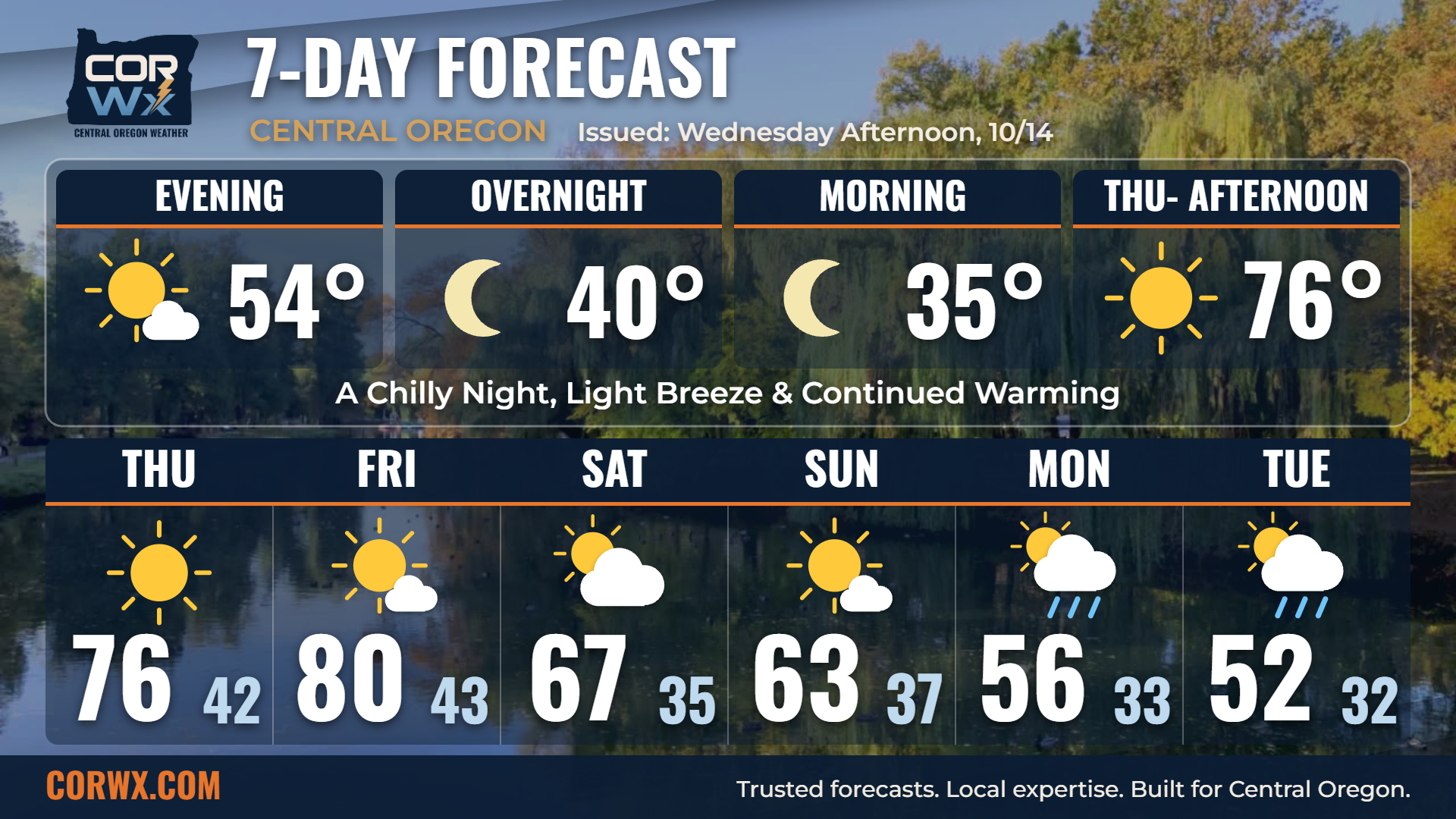
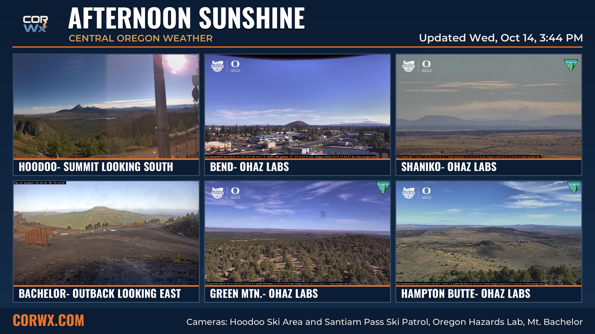
October is giving Central Oregon a pretty good reason to get outside this week. Just don’t mistake Friday’s weather for the start of a new trend. We’ve only got a couple of beautiful afternoons ahead. Get ready for plenty of sunshine and temperatures warming well above where they should be for the middle of October. By Friday, some of our warmer communities could be topping out in the 80s.
The bigger story isn’t necessarily how warm we’re getting. It’s how quickly that warmth disappears. We’re looking at a significant temperature reversal between Friday and early next week, with increasing clouds, much cooler afternoons, and eventually another opportunity for showers.
The Big Picture:
High pressure continues bringing Central Oregon a stretch of dry weather, abundant sunshine, and steadily warming temperatures. Thursday will be noticeably warmer, with Friday shaping up to be the warmest day of the week. Lower-elevation communities across Deschutes, Crook, and Jefferson counties will see the most impressive warmth, although some areas will also experience breezier conditions and very low afternoon humidity.
By the weekend, get ready for a gradual cooldown before a more substantial temperature drop early next week. Clouds will increase and scattered showers return Monday into Tuesday. The temperature change is the more significant and straight-forward part of this forecast.
The forecast remains keeps sunshine & warming through the end of our workweek, with the point forecast guidance showing strong spatial consistency in dry conditions across the lower elevations. Forecast uncertainty increases early next week, particularly regarding the depth of the incoming cooler air mass and whether sufficient moisture will accompany the developing pattern change. The precipitation signal remains weak (for our weaker weekend system), suggesting that any meaningful rainfall will depend on the timing and strength of individual disturbances.
What’s Next:
An upper-level ridge will continue strengthening over the Pacific Northwest through Friday, promoting subsidence, sunshine, stability and warming throughout the lower atmosphere. The combination of sunshine and a relatively dry air mass will help afternoon temperatures climb well above seasonal averages. Southeast flow will also strengthen Thursday into Friday, particularly across exposed terrain and portions of Crook and Deschutes counties.
Strong daytime heating and dry boundary-layer mixing will drive afternoon humidity into the teens and 20s, with southeast flow enhancing winds along exposed terrain. As the upper-level ridge weakens this weekend, cooler air will spread into the region. The timing and strength of the approaching trough will determine whether sufficient moisture and lift develop for showers early next week.
By the Saturday, the ridge begins breaking down, allowing cooler air to gradually spread into the region. The more significant change arrives early next week as the pattern becomes increasingly unsettled. Temperatures will fall considerably from Friday’s peak, with additional cloud cover and a limited opportunity for precipitation.
Let’s Take This Day by Day:
Tonight– Mostly clear and chilly, with light winds and colder conditions in sheltered valleys.
Thursday– Plenty of sunshine and warmer temperatures. Locally breezy with increasingly dry afternoon conditions.
Friday– The warmest day of the week. Sunshine dominates, with some lower elevations approaching 80 degrees.
Saturday– Still pleasant but noticeably cooler. Partly cloudy skies and generally dry conditions.
Sunday– More seasonable temperatures with a mix of sunshine and clouds. Most communities remain dry.
Extended Outlook:
Monday and Tuesday bring a more substantial cooldown, with afternoon temperatures dropping well below Friday’s levels. Increasing cloud cover accompanies the changing pattern, and a slight chance of showers develops across the region. The latest guidance favors relatively limited precipitation, rather than a widespread soaking rain.
Higher elevations could receive a few snow showers if enough moisture overlaps with the colder air. Get ready for roller coaster temperatures. Warming peaks Friday and cooling bottoms out, Tuesday.
The early-week precipitation signal remains modest, with probabilities generally around 10–30% across lower elevations. Increasing cloud cover and stronger winds without a significant rise in precipitation chances suggests limited moisture depth or insufficient large-scale forcing for widespread showers. Higher elevations could receive isolated snow showers as colder air moves into the region, although snow levels and accumulation potential remain uncertain. Additional thermal-profile guidance will help determine whether sufficient cooling and moisture overlap to support meaningful snowfall.
Impacts:
The combination of unusually warm temperatures, low humidity, and occasional southeast breezes Thursday and Friday will produce notably dry afternoon conditions. Outdoor burning and other potential ignition sources deserve extra caution, especially in exposed locations.
The other consideration is the temperature swing. Chilly mornings will continue despite the afternoon warmth, and the return to cooler weather early next week will be especially noticeable for anyone planning outdoor activities. Friday offers the most favorable conditions, while the weekend remains largely dry but cooler.
Final Thoughts:
The primary forecast questions moving forward involve the rate of cooling after Friday, the evolution of cloud cover and whether the early-week disturbance develops enough moisture and lift to generate measurable precipitation. The temperature trend is well represented across the available point forecasts, while the precipitation forecast remains considerably less certain.
Friday should be a beauty, and there’s plenty to like about the next couple of days. Just remember, the atmosphere is already setting up another change. By early next week, we’ll be back to cooler afternoons, colder mornings, and perhaps a few showers.